Tuesday, October 29, 2013

Day 6: Yosemite National Park (20th anniversary day)

Day 6: Yosemite National Park (20th anniversary day)


July 31 was our 20th anniversary day, and was among the finest days of our trip. We drove to Glacier Point, then down to Wawona at the southern entrance of the park.


Morning sun at the campsite. Photo by Sarah.


Official 20th anniversary picture. At Tunnel View with haze from the distant fires settled in Yosemite Valley. Photo by Kenny.


At Glacier Point. Looking across the valley to Yosemite Falls, which was dry during our visit. Photo by Blake.


Liberty Cap, Vernal Falls, and Nevada Falls from Glacier Point. Vernal Falls, to which we hiked the previous day, is at the bottom center of the image. Photo by Blake.


Half Dome from Glacier Point. Photo by Blake.


This is Swinging Bridge, where we went to swim rather than to swing. It’s on the south fork of the Merced River near Wawona. We stayed here for most of the day. Photo by Blake.


Kenny and Sam loved swimming in the river and Sarah found a nice boulder upon which to read, write, and nap. Photos by Blake.


El Capitan. Photo by Sarah.


We wandered around the lower valley for a while on our way back to the campsite. The haze had cleared a bit during the day and the late-afternoon light was quite lovely. It was good end to our anniversary day and our last full day in Yosemite. This day only reiterated that Yosemite is well-deserving of a return trip. We would love to explore in late spring when the waterfalls are at their peak, and we want to hike deeper into the backcountry, especially in the High Sierra. This trip provided a mere taste. Photo by Sarah.

Sunday, October 27, 2013

Day 5: Yosemite National Park

Day 5: Yosemite National Park


If you’ve got to visit Yosemite in the summer and want to avoid the frightening zombie hordes of people, get up early. Most people were still eating each other, er, fixing their pancakes, eggs, and bacon at the crowded valley campsites by the time we headed up the Mist Trail. Although it was initially difficult to find the desired parking lot, we enjoyed that visitors have to take a free shuttle to get to the Yosemite Valley trailheads (excellent use of our federal tax dollars and park fees, as far as we’re concerned).


The morning light was quite beautiful as we ascended the trail along the Merced River up to Vernal Falls and Nevada Falls. Photo by Sarah.


Pausing for a break at the bridge. Smoke from the distant fires is visible in the background. It had settled in the valley for the morning, but blew out as the day progressed. Photo by Sarah.


Vernal Falls. Although the trail to the top of Vernal Falls is only 1.5 miles, there’s an elevation gain of 1000 vertical feet. By July, the waterfalls in Yosemite are either low or dry. Vernal is running low in this picture. Others such as Yosemite Falls were dry and the water in Bridalveil Falls was completely evaporating in the air. Photo by Blake.


The last bit that ascends to the right of this image is quite a grind up 600 steps cut into the rock. Photos by Blake.


Sam wanted to find his own route. Photo by Blake.


Base of Vernal Falls. Photo by Blake.


This is a view of the trail from the top of the falls. In the short time we were at the top, the numbers of people coming up the trail increased dramatically. We so enjoyed the quiet morning hike that we decided to head down before the area became unpleasantly crowded. We stopped for another rest at Emerald Pool at the top of Vernal Falls before heading back. Photo by Blake.


We rode the shuttle back into Yosemite Village and checked out the museum, the Ansel Adams gallery (which disappointingly had only a couple vintage photographs to view), and picked-up some provisions at the village store. Here are Kenny and Sam communing with John Muir. Photo by Blake.


Sarah back at the campsite. Photo by Blake.


Kenny and Sam’s excellent fire. When the zombie hordes attack and we flee to the wilderness, at least the kids will know how to make a fire and cook. Photo by Blake.

Saturday, October 26, 2013

Day 4: South Lake Tahoe, California to Yosemite National Park

Day 4: South Lake Tahoe, California to Yosemite National Park


South Lake Tahoe, California is an interesting place. It’s a ski village right over the state line from Nevada; on the Nevada side are multiple high-rise casinos popping-up out of the pines, and on the California side is the kind of skiing community we might readily find near home in Colorado.


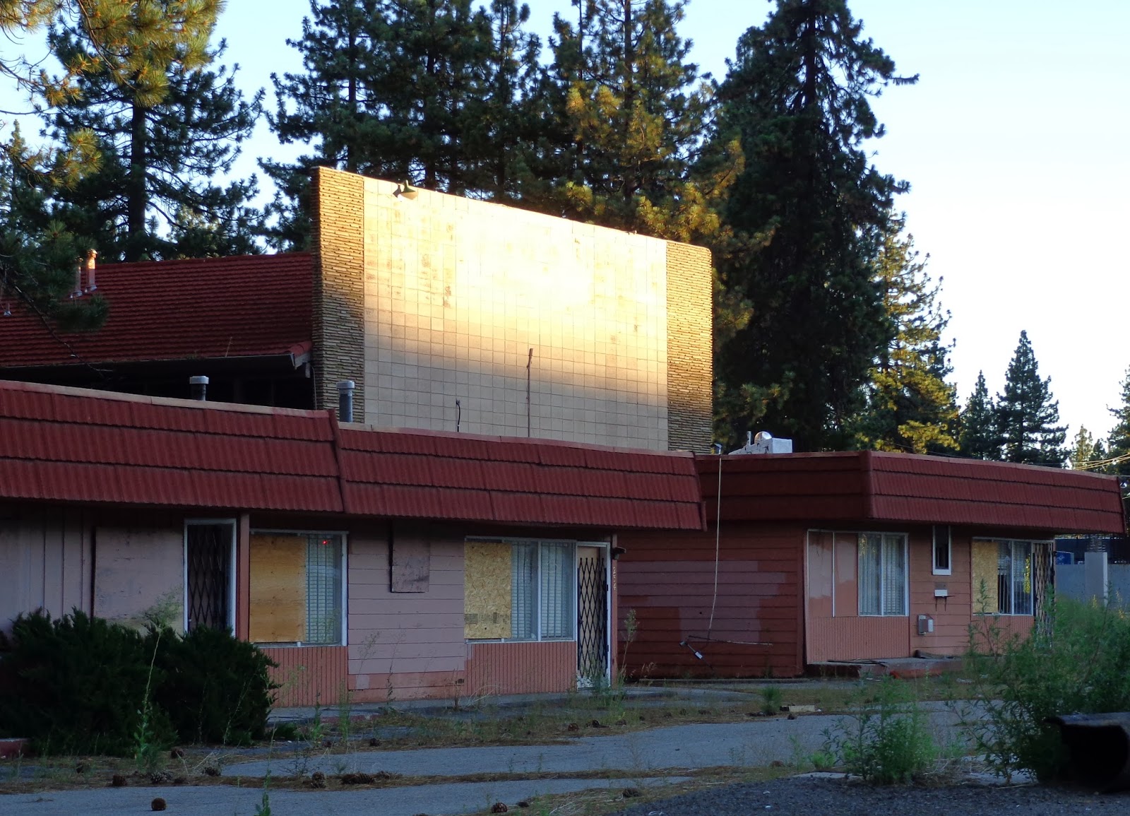
I went for a walk at about 6:00 am to explore and find coffee. The air was cool and the town was pleasantly quiet. I passed by this old motel as the first bit of sunlight peeked over the mountains. Had I turned the camera just to the right of this motel the high-rise casinos would be in the picture, and the upscale ski village was just across the street from here. The ramshackle motel was more interesting. The only coffee shop open at this time of morning was of course a Starbucks. Lake Tahoe itself was magnificent; the town of South Lake Tahoe was not. We were anxious to get underway to Yosemite. Photo by Blake.


Driving south through the Sierra Nevada Mountains was fantastic. Having been sculpted by both glacial and volcanic activity, they are a different kind of rugged than the Rocky Mountains. The drive was a bit stressful as a “low tire” indicator lit up in the rental car just after we ascended into the mountains. All our gear was packed tightly and strategically into the trunk (boot) on top of the spare tire and Blake did not look forward to unpacking it, changing a tire on a mountain road, and packing it all back in. A flat tire never occurred and it’s possible that the oversensitive tire sensor was confused by cold air and high altitude. All morning we’d driven through the mountains under amazingly clear blue skies and were greeted with this hazy scene as we crested the pass just north of Mono Lake. This kind of smoky haze is all-too familiar to us after two summers of intense and destructive wildfires near home in Colorado Springs. That’s the lake at the upper left of the image. To the right, the mountains rise toward Yosemite National Park. As that was our route, the presence of smoke was concerning; but we also know that such smoke can travel hundreds of miles from the fire itself. So on we go. Photo by Blake.


We were looking forward to hiking down to the banks of Mono Lake to see its limestone tufa formations up close, but the thick smoke prevented us from wandering too far. A ranger told us that the fires were indeed many miles away, south of Yosemite, and posed no concern here except for the oppressive and unhealthy smoke. We agreed that we’d like to come back here sometime when we could explore further…and breathe. Photo by Sarah.


Blake and Kenny up the hill from Mono Lake. Photo by Sarah.


Kenny, Sam, and one big-ass hunk of volcanic obsidian. Photo by Blake.


Thankfully, as we ascended Tioga Pass to an elevation of almost 10,000 feet above sea level into Yosemite, the air cleared a bit. Tioga Road winds up the right of this image. Photo by Sarah.


Sam, Kenny, and one big-ass hunk of glacial-and-weather-polished granite. We stopped to have a lovely picnic lunch at Lembert Dome (pictured) near Tuolumne Meadows in Yosemite. Photo by Blake.


Sarah at Tenaya Lake. Photo by Blake.


At Olmstead Point with Half Dome in the background. Photo by Sarah.


From above Olmstead Point. Photo by Blake.


Tenaya Lake from above Olmstead Point. Photo by Blake.


We camped at Crane Flat, about a 20-minute drive from Yosemite Valley, for our four nights in the park. We really enjoyed the campground – it was very green, shady and cool, relatively quiet, we slept well here, there were trails into the forest, and we walked to a ranger-led bear lecture on our first night (although we see more bears around our house in Colorado than we did in Yosemite, which is to say that we’ve seen three bears at the house and none in Yosemite). Speaking of bears, one of the genius aspects of our camping experience on this trip was to make, um…let, the kids sleep in their own tent. After four days of driving and three nights in different places, it was nice to set up camp, put all our edible stuff in the bear-proof box, and be able to come back to the same place for several nights in a row. Photo by Blake.

Thursday, October 24, 2013

Day 3: Ely, Nevada to South Lake Tahoe, California

Day 3: Ely, Nevada to South Lake Tahoe, California


Highway 50 across Nevada is called “The Loneliest Road in America,” apparently due to the desolate landscape through which it passes. We did indeed encounter only a few other travelers along this five-hour drive. The landscape was arid, open, and unpopulated except in the few small towns along the way. There were, nevertheless, many traces of historic mining and ranching activity. The road also crosses the old Pony Express route in a couple places.


Along highway 50. Photo by Sarah.


Ruins of New Pass Station, west of Austin, Nevada. This was a stagecoach stop in the 1860s, but it fell into disuse after completion of the transcontinental railroad. As with many of the frontier settlements here, it was situated near a natural spring. Photo by Blake.


Pony Express station, Cold Spring, Nevada. This was an interpretive structure near the original site. The picture gives a good idea of the harsh landscapes that Pony Express riders had to endure in the nineteenth century. The route extended about 1900 miles from St. Joseph, Missouri to Sacramento, California. Photo by Blake.


Rock text near Fallon, Nevada. Fallon is one of two places on this trip through which we passed on our 1991 trip from Houston, Texas to Portland, Oregon. The other intersection was Las Vegas, but that’s a blog post for another day. Photo by Sarah.


This day’s long drive across the dry interior of Nevada was rewarded as we passed through Carson City, up over a mountain pass, and dropped down to Lake Tahoe. We stayed in South Lake Tahoe, where we could walk down to the lake in one direction and to a brewpub in the other. Fantastic! Photo by Sarah.


Kenny and Sam could have happily stayed here for the entire trip. Photo by Blake.


Sarah. Photo by Blake.

Tuesday, October 22, 2013

Day 2: Green River, Utah to Ely, Nevada

Day 2: Green River, Utah to Ely, Nevada


We got an early start out of Green River and headed for Goblin Valley State Park and Little Wild Horse slot canyon, about an hour’s drive southwest. The morning was cloudy and cool, which meant a good start for Sarah. On the way, we observed distant areas of rain, which wasn’t much of a problem for our experience at Goblin Valley, but meant that Little Wild Horse Canyon was not an option due to the possibility of flash flooding.


The promise of rain and early hour meant that we had Goblin Valley almost to ourselves. This place was an absolute delight to explore. Photo by Blake.


Sam at Goblin Valley. Photo by Sarah.


Kenny peeking through a hole in the rock. Photo by Blake.


Blake at Goblin Valley. Photo by Sarah.


Goblin Valley was among the most memorable sites we visited on our trip. The images above represent the kind of fantastic rock formation destroyed by Boy Scout “leaders” on October 11. The actions of imbeciles like these are disgusting and selfish. Photos by Blake.


San Rafael Swell near Goblin Valley. Photo by Blake.


Eagle Canyon Rocks, Photo by Blake.


While the rains we saw earlier in the day would have made for a dangerous slot canyon excursion, it made for beautiful views while driving later in the day. The rain became quite heavy as we drove through western Utah. This is Sevier Lake in western Utah, which is intermittently dry. Photo by Blake.


After crossing into Nevada, we had hoped to see some of the bristlecone pines at Great Basin National Park, but were foiled by the weather. So we drove on to Ely, Nevada. Casinos like the one pictured seemed to be the only places open, but we found a very good Mexican restaurant called La Fiesta that happily accommodated Sam’s allergy necessities. It was one of Sam and Kenny’s favorite meals of the entire trip. Photo by Sarah.